
Oath essentially remembers three things. First, it remembers a portion of the game's map, which also holds the various rules modifications in play. Second, the game remembers many of the characters, enterprises, and ideas of the previous game in the form of the game deck. This deck will also change from game to game based on how the previous game was played. Finally, the game remembers how it ended, and will adapt the victory condition for the next game in response to this victory condition.
Today, I want to talk about the game's map. The map was essentially the last primary design element that came into shape. I knew early on in the design how I wanted the deck to grow and change in between games and, while I burned through a dozen different versions of the victory system, I had the idea more-or-less outlined long before I built the game's action structure.
The map was different. Part of this was a purely physical concern. I wanted a map that could change during the game and then be held in-between games. To this end, I constructed some truly zany prototypes, wondering If I could reduce things to a single sheet of lego-like pieces or if I needed some kind of reusable sticker system. I hated the latter idea mostly for aesthetic reasons. I also didn't want any system that would fill up or seem to approach an end point the way, for instance, a group's Gloomhaven board will gradually be colored in over the course of many plays.
:strip_icc()/pic2713619.jpg)
One game I took a close look at was CMON's upcoming Trudvang Legends. Trudvang had been announced a few months after I had been working on Oath, and I was intrigued how they were going to approach some of the problems I was tackling. I had little doubt that the two games would be as different as night and day (or as Rising Sun and Root). When I actually saw the game revealed, I admired the ingenuity of their pouch board, but knew it wasn't for me. The map was still largely static. But, more than that, it just couldn't hold that much information. It looked like it could perhaps hold ten or so cards. I needed something more flexible.
Basically I needed two things out of my mapping system. First, I needed it to be adaptable, carrying with it real distances and board development. Second, the map system had to be easily store-able and take less than a minute to setup.
At one point I drew up extensive plans for a ribbed scroll map that could hold flat plastic pieces and could be rolled and unrolled as players needed. I even had a cute idea where the map could gradually re-center itself based on how the game was going by un-scrolling or re-scrolling the map up during play.
But it never worked in practice. Not only would such ventures have been excessively complex, it just wasn't clear what sorts of information I wanted the game's map to carry. Once again, problems of scope reared their head.
Around this time I revisited an old favorite game of my, The King of Dragon Pass. KoDP is a masterpiece both as a piece of traditional interactive fiction and as formidable strategy game. One thing about the game that really impresses me is how well-suited the design is to the scale of it's storytelling. In the game you run a small tribal group. Aided by your usually loyal counselors, you will help guide your little tribe to regional supremacy. The conflicts of the game (and their stakes) are relentlessly personal. A refugee has arrived, do you take them in? Should you steal your neighbor's herds in order to make up for the year's weak harvest? A rival tribe is inviting you to a feast; should you accept their invitation or is it a trap?
/pic5040757.jpg)
Playing this game, along with the reading I talked about last week, lead me to lower my ambitions for the game and fix the game to something like a national (or proto-national) scale. This thought led me to another. Perhaps I needed to adapt how I was thinking about space itself. While working on the game's map, my biggest persistent barrier was that I always wanted my boards to look like maps. A game's board should have places and connections, like a risk map or a traditional wargame. This is a fine enough thing in most cases, but it was a fundamentally bad starting place for me. I didn't need to give players a map of the world, I needed to give them a mental map of the world. Mental maps don't behave anything like real maps! They are full of paths and relative distances, suppositions, and impressions.
I went back and read through some of the source material for the book and was struck by the way the authors often described space. You'd have a hard time making anything like an intelligible map from their descriptions. Instead, their descriptions tended to work in terms of regions. There was a close center, filled with connections and certainty. There were places a little far off, but still near to home. Then there were remote places. Distant from both home and from other remote places.
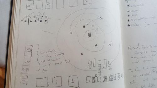
I went to my notebook and scrawled an illustration. Perhaps all of that Wallerstein and core/periphery theory I had read as an undergraduate was useful after all!
:strip_icc()/pic5040763.jpg)
Usually my notes look better than this.
These terms gave me a new way of thinking about space. In most games, space is smooth—heck, that's true in most of our daily experience as well Take out your phone and scroll around the map for a little bit. The geography of the world has little agency compared to the speed of your finger. Your perspective glides seamlessly over all sorts of different spaces. This fits pretty nicely into all of those platitudes about the elimination of space and time in the modern age. Perhaps because we spend so much time using cars, trains, and airplanes, it's easy to imagine yourself move across the map as easily as it renders in your phone screen.
But, if you've ever been in a car that's broken down on the highway, you have likely have second, more terrifying view of space. You know how little of space is actually smooth. The ground near the highway, which looked so flat from the window of a moving car is, in realty, knobby and strange. It's unpleasant to walk on. The next exit, a mere three or four miles away, means for a very long walk, and, even when you arrive, you have to negotiate a dangerous set of crossings to actually get to the repair shop that lies in a place not designed for foot traffic.
I wanted to have these kinds of breakdowns in Oath. I wanted the world to feel sometimes very vast and sometimes very close.
To that end, I build a moment systems around three types of space which doubled as three regions: the Cradle, the Provinces, and the Hinterland. It's easiest to imagine them as sections of a circle, from the middle to the edge.
The distance between one site and another site depending on two things: where are you and where did you want to go. There's nothing too remarkable in this—heck, the same could be said of Risk! But, in this version, I wanted the sense of proximity to change depending on how far away you were from the core of the map. In other words, if you want to move from one part of the edge of a circle to another part, it might be just as easy to go back to the center first and then out again.
:strip_icc()/pic5040780.png)
Here's an image from a concept document back when I was calling the game Saga. On the left you can see that the travel time "T" changes based on where you are.
I didn't want to fully regulate space by superimposing a grid or something to figure out distance. I wanted the region designations to be central. This meant, for instances that every site in the Hinterland was equidistant from each other Hinterland site (and well as each other site in any other region). This may seem like a goofy abstraction, but it provided a much simpler framework for thinking about distance in the game. Instead of having to calculate the movement cost of each hex and its terrain modifier, a player could just look at two locations and any powers they might have (or that might exist on the sites) that would modify this and pretty instantly know how far away something was. Essentially, this gave me a kind of midpoint between the highly rough space of many wargames and the totally smooth space of most euros.
I also loved how easily the new map could be re-centered as well. If a player won the game without ruling the traditional capital of the game, they could chose a new capital and the map could then be re-centered, elevating certain sites to the central region and pushing out other regions into the hinterland.
Storing the Map
Here I need to say a little bit about the function of the map in play. The map is made up of a number of sites which can each host a number of cards. The cards represent the many characters and institutions that populate this world (and change the nature of the game). Essentially the game's map is a shared tableau, which all of the players help build and tear down. This world-building is powered by a somewhat complex zero-sum card economy which I'll be talking about in the next diary. For now, just know that there are usually anywhere from 5 to 15 or so cards in play that most are explicitly linked to various sites in the game.
When a game ends, the territory controlled by the winning player will form the map for the next game. This means that the various game-altering powers that enabled that player to win will form the shared starting point for what happens in the future. Sometimes, especially if The Commonwealth remains in power, the starting map will grow and develop. Sometimes, if some upstart toppled the regime, the next game map will only contain a single site and a new map will have to be mapped and developed around that fresh start.
Though I was happy with the numbers and relationships that my circle model provided, I wasn't sure how to store the map. Around this time I was watching a lot of documentaries on YouTube about early game programming and programming more generally. I was especially interested in memory management and the fundamentals of how computers actually understood a program. I watched a lot of 8-Bit Guy documentaries and Ben Eater's video's on breadboard computers during my spare time.
Though I can't quite remember a breakthrough moment or the specific video that triggered it, at some point I realized that, with the help of region dividers, I could create a simplified version of my circle map as a 1-dimensional array. Then, if the site cards and the regular game cards were two different sizes, the array could be stacked as a pile and then exploded into a map.
So, for instance, imagine a stack of cards. We'll use 0 for a site, 1 for a card, and X for a region divider.
A pile of cards might have this order: 01101X0111X01011
And, following a pretty easy set of instructions, a player could “deal” out the world which would look like this on the table:

Perhaps you see what I mean about how I may have been inspired by watching a bunch of nerdy retro-computer YouTube videos!
In any case, this gave me the piece of the puzzle I was missing. A map could now have complex spatial relationships and always be packed away in a single little box and then easily unpacked without losing any data. And, perhaps best of all, it was so simple! I wasn't going to have to beg our production team for any special and expensive board. This last point was an especially good thing, because it looked like the game's production was going to be a little tricky in another regard which I'll talk about next time when I get into how the game uses cards and how its central deck changes from play to play.
- Cole Wehrle
See the full discussion on the original post on Board Game Geek!